MarineLabs-Homepage-Authorities

Marine Pilotage and Tug Operations

CoastAware’s real-time and forecast data enhance navigational safety, reliability, and efficiency for pilots and tug operators. Supporting weather-critical...
Learn More
MarineLabs-Homepage-HarborAuthorities

Port Operations

Comprehensive coastal intelligence and critical berth-depth data that optimizes port operations, enhances safety, and brings confidence to weather-based...
Learn More
MarineLabs-Homepage-CoastalEngineers

Coastal Engineering

Rely on our real-time, historical, and forecast data, as well as vessel wake analysis, to enhance coastal modelling, support flood and erosion studies,...
Learn More

CoastAware

Transforming Maritime Operations with AI-Driven Coastal Intelligence

CoastAware offers unmatched real-time insights for maritime safety and operations. Our subscription platform, leading in marine weather technology, provides users with detailed, actionable data for informed decision-making.

Validate Critical Decisions and Improve Safety

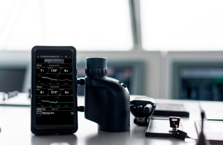
Key Features of CoastAware

Robust Network of Real-Time Sensor Nodes

Currently North America-wide and rapidly expanding with new commissioned locations and conversions of navigational aids into data sites.

AI-Driven Forecasting and 
Weather Modelling

High-quality, hyper-local and accurate 10-day weather forecasts.

Fully-Managed, Hassle-
Free Operations

No need for costly buoy maintenance or operations, with an expanding sensor network that provides data redundancy for continuous insights.

Subscription Benefits

Real-Time Updates and API Integration

Stay informed with up-to-the-minute updates and easy integration into your systems.

Customizable Alerts
and Dashboards

Tailor the platform to your specific needs with customizable alerts and user-friendly dashboards.

Flexibility and Reliability

Choose from existing sensors in our network, commission new locations, or convert navigational aids to suit your regional needs.

More Accurate, Hyper-Local Forecasting

Hyper-Localized

10-day wind and wave forecasts that account for the unique characteristics and geography at each location you subscribe to.

Unmatched Accuracy

Bias-corrected weather forecasts based on advanced machine learning models trained on actual local observed data and trusted third-party models.

Dependability

Stay ahead of the most extreme weather with accurate weather forecasts you can depend on for planning and decision-making.

Learn more about Forecast AI and Download the White Paper: Advantages of Hyper-
Localized AI Metocean Forecasting for Port Operation Decision Making

User-Friendly, Customizable Display

Dashboard View

At a glance, real-time display of the weather conditions where you operate. Everything you need to know on the water, optimized for your mobile device.

Desktop View

The complete software suite, integrated with all of the current and historical data. Download, export, explore, and compare between different coastal locations.

Fleet View

At a glance, overview of weather conditions across multiple locations. Fleet view allows operators, dispatchers, and control rooms to monitor the real-time and forecasted conditions across their subscribed locations in a single streamlined interface.

Coastal Images

Triple Island Pilot Boarding Station, Prince Rupert, B.C.

Real-Time Visuals

Enhance your data with visual context from remote coastal locations. Our BuoyCam technology offers historical and real-time 360-degree views for comprehensive weather condition assessment.

Persistent and Reliable Service

Over 95% uptime with real-time alerts, alarms, and redundancies.

Easy Access Anywhere

Seamlessly integrate real-time images with weather data, accessible on PCs, mobile devices, or through an API connection.

CoastAware’s Impact on Maritime Operations

Learn more about MarineLabs’ Technology